|
The
area in question.....
The Top End is the northern region of Australia - usually of
the Northern Territory, but often also the northeastern portion
of Western Australia and encompasses the many islands off the
northern coastline including Groote Eylandt, Bathurst and Melville
Islands and archipelagos like the Wessel Islands.
The Top End of
the Northern Territory is generally regarded as the northern
portion of the Northern Territory lying between the WA border
(Joseph Bonaparte Gulf) and the Qld border (Gulf of Carpentaria)
as shown in Map 2., or more precisely,
north of about 170 S Latitude
and between 1290 E and 1380
E Longitude. This also means it's well north of the Tropic
of Capricorn, so it's a tropical monsoonal environment with
distinct Wet and Dry seasons.
Arnhem Land is
an area within the Top End, which prior to the establishment
of the Arnhem Land Aboriginal Reserve in 1931 equated with
what is now generally known as the Top End (from the Daly
River east to the Roper River). Arnhem Land then is that area
stretching east of Kakadu (the Arnhem Land Plateau) as far
as the Gulf of Carpentaria, some 150 000 km2.
This entire region is private Aboriginal Land and as
such, permits are required by the Northern
Land Council to enter the region.
|
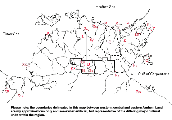
Map
2. Location map showing the
Arnhem Land Aboriginal Land Trust (areas W,
C & E)
and the Beswick Aboriginal Land Trust (area B)
including key townships and communities. Abbreviations
are used for visual clarity.
 Run
your cursor over the map - wherever the cursor appears
as a hand you may click for more detailed information,
or simply click the links below.
Run
your cursor over the map - wherever the cursor appears
as a hand you may click for more detailed information,
or simply click the links below.
| Ba
- Barunga |
Gu
- Kunbarllanjnja |
Ng
- Ngukurr |
| Be
- Wugularr |
J
- Jabiru |
Nh
- Nhulunbuy |
| Bo
- Borroloola |
K
- Katherine |
Nu
- Numbulwar |
| D
- Darwin |
Ku
- Kununurra |
PK
- Wadeye |
| EV
- Manyallaluk |
LE
- Gapuwiyak |
R
- Ramingining |
| Ga
- Galiwinku |
M
- Maningrida |
W
- Wyndham |
| Go
- Goomadeer |
Mi
- Milingimbi |
Y
- Yirrkala |
|
Place
name changes
Many Aboriginal
settlements in the Top End have had name changes in
the last twenty years. Obviously this is not a comprehensive
list, but maybe useful for those interested and/or unable
to find some names on current maps:
|
|